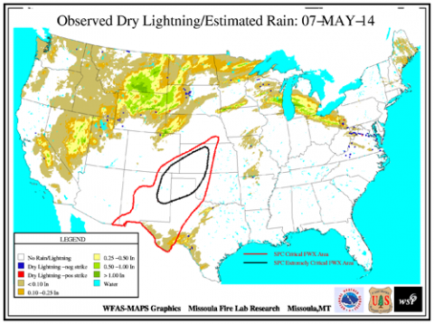
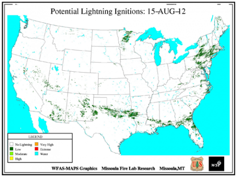
Mapping Potential Dry Lightning Strikes
Dry lightning refers to strikes that produce 0.10 inch or less of rainfall nearby (or 0.25 inch east of the Mississippi River). This kind of lightning storm occurs frequently in the western U.S. during the summer months and is the most common source of natural wildland fire ignitions. Thus, being able to anticipate dry lightning storms is of particular interest to land managers. Recent dry lightning research has concentrated on using upper air measurements—atmospheric stability and moisture content—to predict dry lightning episodes in advance.
FFS Physical Scientist Paul Sopko has integrated this and other research to produce detailed maps that provide land managers with maps to identify potential lightning ignitions and where dry lightning has occurred immediately after the storms have passed. Both maps are created daily to help managers identify areas that have a high likelihood of new lightning-caused wildland fire ignitions.
Image 1: Pixels with dry lightning strikes (negative strike – blue, positive strike – red) and 24 hour estimated rainfall. Areas that the Storm Prediction Center has highlighted for severe fire weather conditions (critical and extreme) are outlined in red and black.
Image 2: Pixels with dry lightning strikes (negative strike – blue, positive strike – red) and fuel “dryness” levels. Dryness level is a combination of one or two fuel dryness and/or fire weather indices that correlate well to large fire occurrence. Areas that the Storm Prediction Center has highlighted for severe fire weather conditions (critical and extreme) are outlined in red and black.
Image 3: Pixels with calculated potential lightning ignitions based on the current lightning efficiency, fuel type and lightning strike data. Pixel value is number of potential fires and is categorized similar to the fire danger rating system