The Upper Tenmile Watershed is located southwest of the City of Helena, Montana, on the Helena National Forest (HNF). The watershed is an important source of drinking water for the city and is also a popular recreational area for nearby residents. The HNF has proposed treating fuels in the Tenmile–South Helena project area which encompasses the 26,000 acre watershed and an additional 35,000 acres to the east of the watershed. The Tenmile–South Helena project proposes hazardous fuel treatments for the purpose of “maintaining consistent water quantity-quality within Helena's municipal watershed and improving conditions for public and firefighters safety across the landscape in the event of a wildfire” (Helena National Forest, 2014).
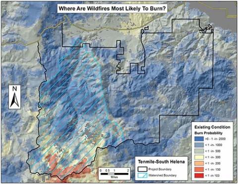
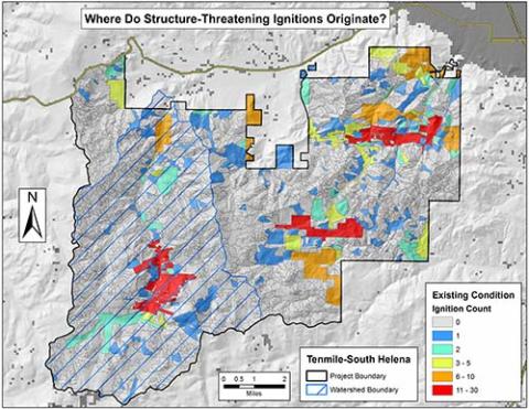
In April, 2015 the HNF requested that the Fire Modeling Institute (FMI) conduct a wildfire probability modeling and risk assessment study to analyze proposed fuel treatments in the project area. The HNF requested this study include modeling the probability of burning, potential fire behavior, and identification of areas where large fires and/or fires potentially destructive to structures were most likely to originate.
This study compared three alternative fuel treatment scenarios regarding their effect on the probability of burning and the potential impacts thereof. Two of the alternatives would apply various combinations of commercial tree harvesting, non-commercial vegetation treatments and prescribed fire (Helena National Forest, 2014) to the Tenmile-South Helena project area. The other treatment scenario, referred to as the ‘existing condition’ alternative, would apply no treatments.
The analyses performed were primarily based on outputs from the large fire simulation model FSim (Finney et al. 2011). FSim combines models of ignition probability, spatial fire growth and suppression with artificially generated weather streams to simulate fire ignition and spread for many thousands of simulation years. It models potential wildfire based on historical weather and fire occurrence data and current fuels data. FSim generates a number of standard outputs including annual burn probability, mean fireline intensity, conditional flame lengths, fire perimeters and a fire size list.
Results were provided to the HNF comparing probability, mean fireline intensity, as well as hazard and risk to structures based on ignition location for each of the three fuel treatment alternatives. This analysis provides insight into the potential impacts of each alternative on future wildfire behavior and risk. These insights will help the HNF select and defend the most effective fuel treatment option.