Wildfires are a major source of air pollutants in the United States. Wildfire smoke can trigger severe pollution episodes with substantial impacts on public health. In addition to acute episodes, wildfires can have a marginal effect on air quality at significant distances from the source presenting significant challenges to air regulators’ efforts to meet National Ambient Air Quality Standards (NAAQS) and improve visibility in National Parks and Wilderness Areas as required under the federal Regional Haze Rule. Improved emission estimates are needed to quantify the contribution of wildfires to air pollution and thereby inform decision making activities related to the control and regulation of anthropogenic air pollution sources.
To address the need of land managers and air regulators for accurate wildfire emission estimates the Fire, Fuel, and Smoke Program’s Smoke Emission and Dispersion Team developed the Missoula Fire Lab Wildfire Emission Inventory (MFLEI), a retrospective, daily wildfire emission inventory for the contiguous United States. MFLEI was produced using multiple datasets of fire activity and burned area, a newly developed wildland fuels map and an updated emission factor database. The fuel type classification map is a merger of a national forest type map, produced by the USFS Forest Inventory and Analysis (FIA) program and the Remote Sensing Applications Center (RSAC), with a shrub and grassland vegetation (rangeland) map developed by the USFS Missoula Forestry Sciences Laboratory. Forest fuel loading is from a fuel classification developed from a large set (> 26,000 sites) of FIA surface fuel estimates. Herbaceous fuel loading is estimated using site specific parameters with Normalized Differenced Vegetation Index (NDVI) from the Moderate Resolution Imaging Spectroradiometer. Shrub fuel loading is quantified by applying numerous allometric equations linking stand structure and composition to biomass and fuels. These structure and composition data are derived from canopy cover, canopy height, and species composition data from the LANDFIRE Project.
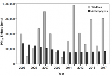
The MFLEI provides estimates of daily wildfire pollutant emissions at a 250 m x 250 m resolution for 2003-2017. Figure 1 compares June – September fine particulate matter (PM2.5) emitted by wildfires with anthropogenic sources (from EPA data) across the western U.S. The figure shows that in most years, wildfire emissions of PM2.5 far exceed the amount produced by anthropogenic sources (e. g. transportation, power generation, industrial processes, and agriculture). Phase 2 of this project will combine daily emission estimates from MFLEI with measurements of pollutant concentrations from state air quality monitoring networks to evaluate air quality forecasting models. Figure 2 maps the perimeters of several fires active in the Northern Rockies during August 17–31, 2017 and the location of four cities heavily impacted by smoke during this period. The line plots show daily average PM2.5 concentrations measured at four monitor sites and the fire perimeters are labeled with the MFLEI total PM2.5 emissions for the period. The Phase 2 goal is to improve the plume-rise and short-term emission forecast models that are critical components of the air quality models used to provide smoke forecasts to public health officials and fire management teams.