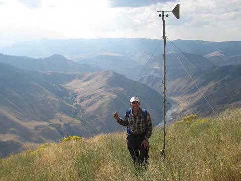
There is a lack of high resolution measurements of wind speed and direction with which to test wind model accuracy. This project is directed at collecting needed data sets in mountainous terrain.
Wind predictions in complex terrain are important for a number of applications including wildland fire behavior, transport and dispersion of pollutants, and wind energy applications. Fine-scale changes in topography and vegetation substantially alter the flow field, and thus, accurate modeling for these applications in complex topography requires near-surface flow field predictions at a high spatial resolution. Two high-resolution wind models with varying degrees of sophistication have been developed at the Missoula Fire Sciences Laboratory in response to these needs; however, evaluation and improvement of these models is limited by a lack of high-resolution datasets in complex terrain under various weather scenarios. In response to this need, FFS Research Mechanical Engineer Bret Butler, with collaborators from Washington State University and the U.S. Forest Service’s Moscow Forestry Sciences Laboratory, collected several high-resolution surface wind datasets over a variety of terrain features and under a range of meteorological conditions. At Big Southern Butte, ID, investigators installed more than 50 weather towers that recorded 10-foot average wind speed, wind direction, and gusts, covering an area of roughly 30 square miles. In addition, they installed four SOnic Detection And Ranging instruments (SODARs), two radar wind profilers, approximately six sonic anemometers, and numerous balloon sondes. These datasets will be used to investigate terrain-induced effects on wind flows, such as mechanical channeling and thermally driven slope flows, as well as to develop and evaluate high-resolution numerical wind and weather prediction models in complex terrain. Preliminary exploration of the data revealed unique local-scale mechanically and thermally driven flow features that will be of interest in future model evaluations. Preliminary model evaluations indicate that wind predictions from routine weather forecasts can be improved in complex terrain by downscaling the data to a fine resolution with the WindNinja model.
For an overview of the field studies and additional details please visit https://weather.firelab.org/windninja/field/
Download the data at https://zenodo.org/records/8226638.
