Quantitative wildfire risk analysis requires complete geospatial coverage of fire impact probabilities and sizes. Wildfire simulation is the primary means of estimating these, including the frequency distribution of large fire events. FSim simulates the growth and behavior of hundreds of thousands of fire events for risk analysis across large land areas using geospatial data on historical fire occurrence, weather, terrain, and fuel conditions. Effects of large fire suppression on fire duration and size are also simulated.
The purpose of this research is to develop a practical method of quantifying geospatial wildfire impacts, including annual probabilities of burning and fireline intensity distributions at any point on the landscape. The distribution of intensity can be combined with assets or values (e.g. homes, habitat, watersheds) using their susceptibility at each intensity level to perform quantitative geospatial risk analyses. Geospatial analyses can also depict
- Annualized expected impact of fire on values or assets.
- Fire size distributions and geospatial event sets (polygons of all simulated fires).
- The transmission of fire from the start locations to the points of final impact
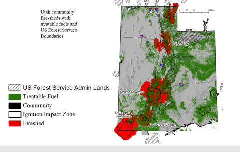
- Summaries of wildfire transmission: defining a “fireshed” – the surrounding area that a fire can start and affect a particular location or asset and a “fireplain” – the areas that can be affected by fires starting in a given location
- Changes in risk resulting from fuel management activities (e.g. prescribed burning).
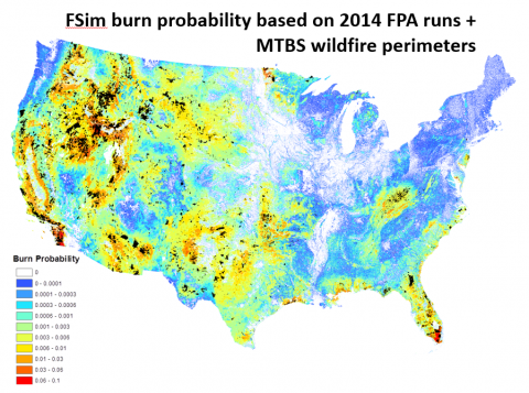
The FSim simulation process involves the following: 1. Assembly of geospatial landscape and terrain data, typically from LANDFIRE 2. Assembly and processing of historical fire occurrence data (Fire Occurrence Database) 3. Assembly and processing of historical weather observations (WIMS, FireFamilyPlus) Using these datasets, the weather data are analyzed to produce a large number of synthetic ‘years’ comprising daily weather sequences. For each day in each year the ignitions are stochastically generated and the growth and behavior of resulting wildfires are simulated as they burn across the landscape. The process continues for the specified number of years, which produces a probability distribution of intensities. These can be summed to obtain the annualized burn probability. The user must calibrate the model results by comparison with observed fire distributions.
- The FSim model has demonstrated that power-law wildfire size distributions are produced by the joint distributions of weather sequences and spatial locations of ignitions. There is no contagion among fires in FSim, thus the distributions of fire sizes are a product of the variability in the environment.
- FSim is used at national scale with relatively coarse resolutions (270m) and regional or local scales with relatively fine resolutions (e.g. 90m).
- The FSim event sets are used by the Reinsurance industry in their exposure calculations of wildfire risk.
- FSim generated outputs comprise the foundation for the national Wildfire Risk to Communities product (https://wildfirerisk.org/)
FSim is period updated with improved algorithms and features. The following datasets are associated with the FSim product: